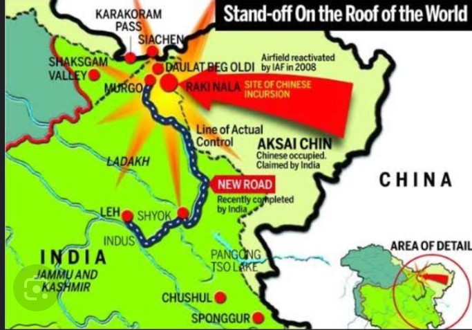
China has released a new official map that underscores its territorial claims by portraying the entire State of Arunachal Pradesh and the Aksai Chin region as integral parts of its territory.
This move is bound to reignite tensions and concerns among neighboring countries and the international community.China’s latest official map has ignited concerns by depicting Arunachal Pradesh and the Aksai Chin region within its borders, reiterating territorial claims.
This move comes against the backdrop of the 2020 Galwan conflict and heightens tensions, raising diplomatic and geopolitical challenges. The depiction serves as a stark reminder of the ongoing territorial disputes and their far-reaching impacts on regional stability.
https://www.drishtiias.com/daily-news-editorials/galwan-valley-clash
The depiction of Arunachal Pradesh and Aksai Chin within China’s borders is consistent with the country’s long-standing assertions. Arunachal Pradesh, a northeastern Indian state, and the Aksai Chin region, an area situated in the northern part of Ladakh, have historically been points of contention between China and India.
China’s new official map carries geopolitical implications that extend beyond cartography. The portrayal of these disputed areas reaffirms China’s assertive stance on territorial claims and signals its intent to maintain its hold on these regions.
This move is likely to strain diplomatic relations, particularly with India, which has consistently maintained that Arunachal Pradesh is an integral part of its territory.
The Aksai Chin region has been a particularly contentious area, with both India and China laying claim to it. This depiction on the official map is likely to further complicate efforts to resolve the border dispute between the two countries. It also raises concerns about the prospects of maintaining peace and stability in the region.
The international community closely watches developments involving territorial disputes, as they have the potential to escalate into larger conflicts. China’s decision to assert its claims through the release of an official map carries diplomatic and strategic implications that extend beyond its immediate neighbors.
The release of this new map comes at a time when global attention is on China’s territorial ambitions and its approach to territorial disputes in the South China Sea and other regions. The depiction of Arunachal Pradesh and Aksai Chin within its borders adds another layer of complexity to these existing concerns.
In conclusion, China’s release of a new official map asserting its territorial claims over Arunachal Pradesh and the Aksai Chin region underscores the ongoing geopolitical tensions in the region. This depiction has far-reaching implications for diplomatic relations and regional stability.
As global stakeholders assess the situation, concerns about potential conflicts and the need for peaceful resolution remain at the forefront.

